File:Maharlika Highway map.png
Jump to navigation
Jump to search
Size of this preview: 384 × 599 pixels. Other resolutions: 154 × 240 pixels | 500 × 780 pixels.
Original file (500 × 780 pixels, file size: 34 KB, MIME type: image/png)
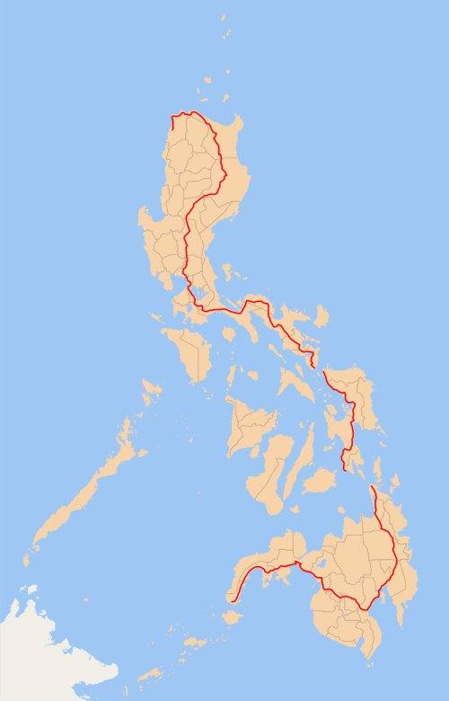
| Description |
English: Map of the Philippines (with provincial borders in grey) showing the en:Pan-Philippine Highway (red). Ferry services connect Luzon to Samar and Leyte to Mindanao, and the en:San Juanico Bridge connects Samar and Leyte.
Made by me, released under the GFDL. |
||||||||
| Date | 17 June 2006 (original upload date) | ||||||||
| Source | Transferred from en.wikipedia to Commons by Ludger1961 using CommonsHelper. | ||||||||
| Author | The original uploader was TheCoffee at English Wikipedia. | ||||||||
| Other versions |
|

Original upload log
The original description page was here. All following user names refer to en.wikipedia.
- 2006-06-17 16:04 TheCoffee 500×780× (34758 bytes) Map of the [[Philippines]] (with provincial borders in grey) showing the [[Pan-Philippine Highway]] (red). Ferry services connect Luzon to Samar and Leyte to Mindanao, and the [[San Joaquin Bridge]] connects Samar and Leyte. Made by him, released under th
File history
Click on a date/time to view the file as it appeared at that time.
| Date/Time | Thumbnail | Dimensions | User | Comment | |
|---|---|---|---|---|---|
| current | 08:28, 6 January 2009 | | 500 × 780 (34 KB) | wikimediacommons>File Upload Bot (Magnus Manske) | {{BotMoveToCommons|en.wikipedia}} {{Information |Description={{en|Map of the en:Philippines (with provincial borders in grey) showing the en:Pan-Philippine Highway (red). Ferry services connect Luzon to Samar and Leyte to Mindanao, and the [[:e |
File usage
The following page uses this file: